More than 100 years ago, a worldwide pandemic moved from China to the entire Western World through in-sourced low wage labor, according to the research of one historian. As the Allies fought WWI, farmers were going to war, and as Napoleon said, “An army marches on its stomach.”
The Allies desperately needed chicken and pig farmers to raise food to be canned for the troops. Some 96,000 Northern Chinese farmers and menial laborers were imported. Everywhere they went a killing flu broke out and then made its way through human contact around most of the globe killing many more people (50 million) than the war casualties of WWI. The German, Austrian and Turkish populations were particularly hard hit, and the so-called “Spanish Flu” played no small part in the end of the war. The first lesson is that borders need to be medically controlled and that closed borders are safer than open ones, especially when there are wildly varying sanitary and health conditions between nations.
The Spanish Influenza was so named because, to most people, it seemed Spain was most heavily hit by the virus. This wasn’t actually true, but because Spain was neutral, it seemed hardest hit due to the fact that its press was not being censored for the war effort. People in the nations fighting the war were not given information about the disease, how it was spread and how to avoid exposure. They would still go to munitions factories and bond rallies, remaining focused on war activities. This allowed the virus to deeply penetrate all of Europe and the United States. The second lesson is that a controlled or dishonest press is an agent of death in a pandemic.
Most of the Spanish flu victims didn’t actually die from the virus. The virus would ravage their bodies, particularly their lungs. Generally, they would recover but be terribly weakened, their lungs etched by the effects of the virus. In their weakened state, the victims acquired bacterial infections. With raw lungs and weakened immune systems, they were unable to withstand the infections.
This led to a cleanliness and anti-bacterial fetish in the Western World from 1920 until roughly 1980. By 1980, we had forgotten the WHY of this fetish and deemed it to be the silliness and unjustified paranoia of our grandparents’ generation. They had no 15-second rule on their fastidiously clean floors for very good reason. The third major lesson is that soap and other disinfectants save lives.
I had not flown on a jet from 1989 until 2016. I had not taken a bus, streetcar or train from 1990 until 2017. As a member of a national not-for-profit board, I have recently been taking public transportation to get around the country. The shabbiness and filth on jets, trains and buses I encountered was shocking.
Presumably as a cost-cutting measure, general filth has been allowed to prevail. This makes public transportation dangerous, in addition to the crowding of people into tight, poorly ventilated space. In the 1918 pandemic, it was noticed that people who used public transportation had much higher infection rates than those who walked, rode bicycles or used automobiles. The fourth lesson is the same today. Mass transit is dangerous during epidemics and pandemics.
Beginning in 1920, there was a huge move of population in the industrialized world from cramped cities to the suburbs. Again the Spanish flu played a major role in Modernist-Progressive preaching that the cramped conditions of cities made them natural breeding grounds for disease. The first train subway founded in Connecticut in the 1880s gave support to this thinking.
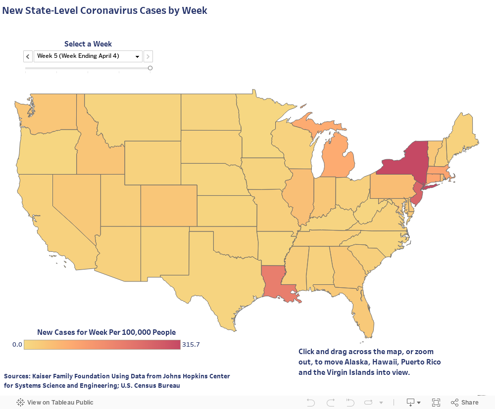
Los Angeles County, famous for being an “automotive metropolis,” was actually laid out in the 1890s as suburbs. The thought process was that even if fathers of families had to risk their lives by working in the city, wives and children would be safe from contagion and also able to exercise and grow some family food. It was seen in the 1918 Spanish flu outbreak that, indeed, tightly packed dense cities had almost double the infection rates as suburbs and rural areas. The fifth lesson in 1918 was clear, as it should be clear today: density kills.
For two decades now, Globalists pretending to be Progressives and falsely flying under our banner have been attempting to remake the world into a global community of open borders, reduced standards of cleanliness and maintenance, lower wages, mass transit and dense urban cores. They have refused the lessons of history that 1918 and all other world pandemics and local health crises have taught us.
At this very moment, as a pandemic rages, the Globalists still demand and promote bail-out packages with open borders, dense and killing mass transit systems, anti-suburban planning initiatives and, insanely enough, more dense cities. Their religion of oligarch profit will not consider reality, instead wanting to enforce an obstinate rigidity against it.
The future is ours. We must seize it for the reality history shows what real sustainability is.
Steven Lamb is a 4th generation Native Californian. He is a past City Council Person and Land Use Commissioner. Mr. Lamb has had a Organic Architecture design practice for thirty five years. Mr. Lamb presently is a board member of Progressives for Immigration Reform and a co founder of the Center for Progressive Urban Politics.